About The Spanish Banks
With great respect, we acknowledge that Spanish Bank Creek is located on the traditional, ancestral, and unceded territory of the xʷməθkʷəy̓əm (Musqueam) people.
The Spanish Bank is a coastal sand bank located on the western edge of the city of Vancouver, Canada. The area is home to a series of sand beaches also called the Spanish Banks beaches between Locarno Beach and the University of British Columbia. Although the first European explorers in the Strait of Georgia were Spaniards who sighted Point Grey in 1791, the Spanish Banks were named in commemoration of the meeting of the English Captain George Vancouver and the Spanish explorers Galiano and Valdés in June 1792. Vancouver’s maps do not show the bank, but Galiano’s charts of 1792 and 1795 do. The Hudson’s Bay Company called the area Spanish Banks for this reason. However, since time immemorial, the area has been a home for the Musqueam First Nation with a diverse ecosystem that supports (and could continue to support) many bird and animal species, and many marine species including salmon. The network of streams and estuaries in the area were particularly important for spawning Pacific salmon such as Coho, Chum, Chinook, and Cutthroat Trout.
The Spanish Bank is a coastal sand bank located on the western edge of the city of Vancouver, Canada. The area is home to a series of sand beaches also called the Spanish Banks beaches between Locarno Beach and the University of British Columbia. Although the first European explorers in the Strait of Georgia were Spaniards who sighted Point Grey in 1791, the Spanish Banks were named in commemoration of the meeting of the English Captain George Vancouver and the Spanish explorers Galiano and Valdés in June 1792. Vancouver’s maps do not show the bank, but Galiano’s charts of 1792 and 1795 do. The Hudson’s Bay Company called the area Spanish Banks for this reason. However, since time immemorial, the area has been a home for the Musqueam First Nation with a diverse ecosystem that supports (and could continue to support) many bird and animal species, and many marine species including salmon. The network of streams and estuaries in the area were particularly important for spawning Pacific salmon such as Coho, Chum, Chinook, and Cutthroat Trout.
Named by the earliest Spanish explorers, Spanish Banks is blessed with three streams that flow north into Burrard Inlet: Spanish Bank Creek is most prominent because it is the closest to Vancouver. Spanish Bank Creek flows north from Chancellor Boulevard for approximately one kilometer, then flows under NW Marine Drive, and terminates at a tidal estuary in the Burrard Inlet. Logging and urbanization that occurred between the 1860s & 1940s led to ecological disturbances in the watershed of the creek, including a decrease in biodiversity of native species and an increase in water runoff. Historically, the greater Vancouver region consisted of many streams and creeks covering a distance of 124 km; however, by 1998, only 10km of open streams remained.
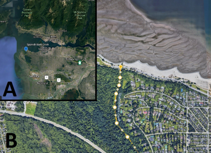
Satellite Imagery taken using Google Earth showing the location of Spanish Bank creek within the Vancouver area (A), and Spanish Bank Creek (B) (Google Earth, 2021).
Restoration of the creek was initiated in 1999 when a section of the culvert connecting Spanish Bank Creek and Burrard Inlet was daylighted. Riparian vegetation was also restored around the lower reaches of the stream. An off-channel habitat (OCH) pond was created in 2004. This pond serves as a refuge for fry who would have otherwise been washed out to sea by periods of flash flow—frequent in the stream due to its straight, relatively unobstructed course. However, the pond is located higher in the creek than most chum travel and is primarily used by coho
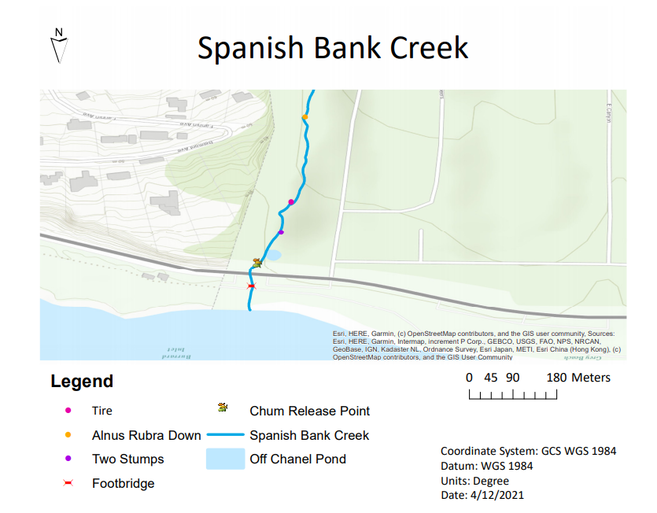
A 2021 Topographic map of the Spanish Bank Creek in Vancouver, BC, Canada.
